GTA 6 Map Size vs GTA 5 & RDR2: Full Leonida Scale & Landmass Analysis
Quantitative three-way comparison of GTA 6’s State of Leonida (~97.6–125.6 km² playable landmass / ~151.8–185 km² navigable world) vs GTA 5 (75.8 km² total / 48.2 km² dry land) vs Red Dead Redemption 2 (RDR2, ~35.9 km² playable land — GTA 6 is ~3× RDR2’s playable area).
Measure All 6 Regions Yourself on the Full-Scale Leonida Map
GTA 6’s State of Leonida spans ~97.6–125.6 km² of playable landmass (~151.8–185.0 km² with navigable reefs, Lake Leonida & Grassrivers) — roughly 2× GTA 5’s 75.8 km² map and ~3× Red Dead Redemption 2’s (~35.9 km²) playable land area, packed with 3,487 verified pins.
Three-Way Quantitative Scale Table: GTA 6 vs GTA 5 (75.8 km²) vs Red Dead Redemption 2 (RDR2)
Players comparing Rockstar Games’ three flagship HD-era worlds often run into conflicting numbers online because some charts measure strict dry land while others measure the entire rectangular water bounding box. Putting GTA 6 (Leonida), GTA 5 (Southern San Andreas), and Red Dead Redemption 2 (RDR2) on identical cartographic standards resolves every discrepancy side by side:
| World Metric | GTA 6 (State of Leonida) | GTA 5 (Southern San Andreas) | Red Dead Redemption 2 (RDR2) | Verified Scale Multiplier |
|---|---|---|---|---|
| Playable Dry Landmass | ~97.6 – 125.6 km² (37.7 – 48.5 sq mi) | 48.15 km² (18.59 sq mi) | ~35.9 km² (13.86 sq mi across 5 states) | ~2.0×–2.6× GTA 5 land; ~3× RDR2 playable area |
| Total Navigable Area (With Water) | ~151.8 – 185.0 km² (58.6 – 71.4 sq mi) | 75.84 km² (29.28 sq mi) | ~75.1 km² (incl. Flat Iron Lake & border mountains) | ~2.0×–2.4× GTA 5’s 75.8 km² total world |
| Regions, Counties & States | 6 regions across 5 counties (Vice-Dale, Mariana, Kelly, Leonard, Lummox) | 2 counties (Los Santos County & Blaine County) | 5 states (New Hanover, Lemoyne, West Elizabeth, Ambarino, New Austin) | Multi-city corridor instead of single-city island |
| Major Urban & Town Hubs | Vice City metro, Port Gellhorn, Ambrosia, Key Lento, Watson Bay, Yorktown | Los Santos + Paleto Bay, Sandy Shores & Grapeseed | Saint Denis + Blackwater, Valentine, Rhodes, Strawberry, Tumbleweed | 3× urban street mileage vs Los Santos |
| End-to-End Top-Speed Traversal | ~11 – 14 min (180+ mph supercar, Keys to Mount Kalaga) | ~7 – 8 min (supercar via Route 1 / Route 13) | ~16 – 19 min (38 mph Arabian horse, Tumbleweed to Annesburg) | High-speed highways still take nearly 2× GTA 5’s drive |
| Enterable Interiors (Free Roam) | 385+ enterable buildings (45 banks, 131 shops, 67 hotels, clubs, pawns) | <45 non-mission enterable interiors in story mode | ~125 frontier cabins, saloons, general stores & homesteads | 8.5× GTA 5 and ~3× RDR2 interior count |
| Usable Terrain Efficiency | ~91% navigable (roads, airboat marshes, trails & reefs) | ~68% usable (steep Mount Chiliad / Josiah rock faces) | ~82% ridable (excluding Grizzlies glacier walls & river boundaries) | Minimal dead rock filler; almost every km² holds POIs |
| Active Interior Water Gameplay | Keys shipwrecks, Grassrivers airboats, Lake Leonida & intracoastal canals | Mostly outer ocean border + Alamo Sea & Cassidy Creek | Flat Iron Lake, Lannahechee River, Dakota River & Bayou Nwa | Boats, jet skis & seaplanes serve as primary heist routes |
| Public Transit & Aviation | 34 Metro stations, 276 bus stops, 11 airfields & marinas | LS Transit light rail, 3 main airfields & helipads | Passenger trains, stagecoaches & camp fast travel (no aircraft) | Full 3D airspace + dense neighborhood transit |
| Verified Interactive Map POIs | 3,487 verified pins across 26 layers (Explore live ↗) | ~1,150 core single-player locations & collectibles | ~1,650 collectibles, hunting zones, stranger spots & carvings | 3.0× GTA 5 and 2.1× RDR2 tracked POIs |
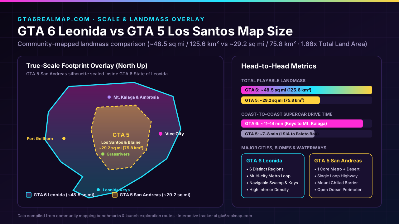
Visual Scale Overlay: GTA 6 Leonida (~48.5 sq mi) vs GTA 5 San Andreas (~29.2 sq mi)
Raw square kilometers only tell half the gameplay story. In Grand Theft Auto V, Southern San Andreas concentrated almost every urban block at the southern tip of an oval island while dedicating nearly a third of its northern footprint to steep, largely empty slopes around Mount Chiliad, Mount Gordo, and the Tataviam Mountains. When you overlay Los Santos directly onto Leonida at identical meter-per-pixel road scale, the structural leap becomes unmistakable:
GTA 6 vs Red Dead Redemption 2 (RDR2): Why ~3× Playable Area Still Feels Handcrafted
Before GTA 6 launched, many players assumed Red Dead Redemption 2 was larger than GTA 5 because riding from Valentine to Saint Denis or across New Austin felt like a genuine cross-country expedition. Cartographically, however, RDR2’s playable dry land measures roughly 35.9 km² (13.86 sq mi) — smaller in raw square kilometers than GTA 5’s 48.15 km² of land, even though RDR2 felt far richer and more expansive on screen. Comparing GTA 6’s ~97.6–125.6 km² of playable land (~3× RDR2’s playable area) against RDR2 highlights three design breakthroughs Rockstar carried forward from RAGE 8 into RAGE 9:
- Travel Velocity vs. World Footprint: In RDR2, top-tier horses travel at roughly 35–42 mph (56–68 km/h), whereas GTA 6 players routinely cruise interstate causeways at 150–195 mph in tuned sports cars or cut straight across Lake Leonida at 140 knots in a free Southwind Buckingham Maverick helicopter or Mammoth Dodo seaplane. Had Leonida stayed at RDR2’s 35.9 km² scale, a supercar would cross the state in under four minutes. Scaling Leonida to ~3× RDR2’s playable land preserves an 11–14 minute cross-state road trip even at modern highway speeds.
- Sightline Framing & Horizon Layering (Bayou Nwa to Grassrivers): RDR2 mastered atmospheric horizon breaking — using dense cypress canopy in Bayou Nwa, rolling heartland ridges in New Hanover, and volumetric mountain mist in Ambarino so you never saw opposite edges of the map simultaneously. GTA 6 applies that exact technique at three times the scale: mangrove hammocks in Grassrivers, sugar-mill smoke and pine belts around Ambrosia, and deep canyon walls in Mount Kalaga National Park prevent Vice City’s neon towers from dominating every horizon.
- Interior & Systemic Interaction Per Square Kilometer: What made Saint Denis unforgettable in RDR2 was seamless door-to-street entry with zero loading screens. GTA 6 scales that seamless interior architecture up to 385+ enterable buildings — letting you case all 8 Large Bank Vaults ($65K–$205K) and 14 Small Branch Banks, scan sticky-note PINs in Focus Mode across 84 safe locations, and raid 39 gang operations without hitting a fade-to-black screen.
All 6 Leonida Regions: Area Share, Biome Role & Live Pin Density (3,487 Verified Pins)
Unlike GTA 5’s binary split between Los Santos and Blaine County, Leonida distributes gameplay across six distinct regions spanning five counties (Vice-Dale, Mariana, Kelly, Leonard, and Lummox). Here is how world scale, traversal vehicles, and our 3,487 verified map pins break down across every region:
| Leonida Region & County | Estimated Playable Share | Primary Terrain & Traversal | Key Gameplay & Collectibles | Live Map Deep Link |
|---|---|---|---|---|
| Vice City & Vice Beach (Vice-Dale County) | ~24% land · Highest vertical density | Multi-island causeways, 34 Metro stops, Ocean Beach, Downtown, Tequesta, Crosstown, VCIA | 7 of 8 Large Bank Vaults ($65K–$205K), dense Collectible Cards, La Perle Flamingo, luxury dealers | Open Vice City ↗ |
| Leonida Keys & Key Lento (Mariana County) | ~14% island land + ~22% navigable reef | Overseas highway bridges (242 Under-Bridge & Knife Flight spans), marinas, shallow dive reefs | Key Lento, Abismo Key & Southwind Cocaine Flamingos, shipwreck cash chests, Brian’s Lockups (7700) |
Open Keys ↗ |
| Grassrivers Wetlands (Mariana / Vice-Dale Border) | ~19% marsh & hammock islands | Airboat channels, stilted smuggler docks, Watson Bay motels, Cottonmouth Lake trails | Cottonmouth trailer safe (44017), Grassrivers & Watson Bay Flamingos, Skunk Ape / Bigfoot trail |
Open Grassrivers ↗ |
| Port Gellhorn & Belpoint (Leonard / West Coast) | ~15% coastal urban & industrial strip | West-coast highway motels, cargo docks, Gellhorn Raceway, Belpoint island | Brooks Boatworks wall map (6823, 6969, 0300), 6 verified Belpoint Flamingos, pawn fences |
Open Port Gellhorn ↗ |
| Ambrosia & Lake Leonida (Kelly County) | ~16% central heartland + inland lake | Refinery freight corridors, agricultural ranches, central Lake Leonida ferries & speedboats | Farm Fix Meth Lab safe (2121), Shorefront Ambrosia & Druthers State Bank, biker turf |
Open Ambrosia ↗ |
| Mount Kalaga National Park (Lummox County North) | ~12% mountain ridges & river canyons | Dirt-bike switchbacks, whitewater kayaks, fire watchtowers, Yorktown backroads | Mount Kalaga Watchtower keypad (691865), ’74 Vamos garage (2727), rare hunting & BASE jumps |
Open Mount Kalaga ↗ |
Watch: Timed End-to-End Drive Tests & Scale Overlay Breakdowns
See how Leonida’s 11–14 minute highway run and multi-island causeway layout feel in real time compared against GTA 5’s Route 1 perimeter loop:
 CosmosFTW
 Saintsfan
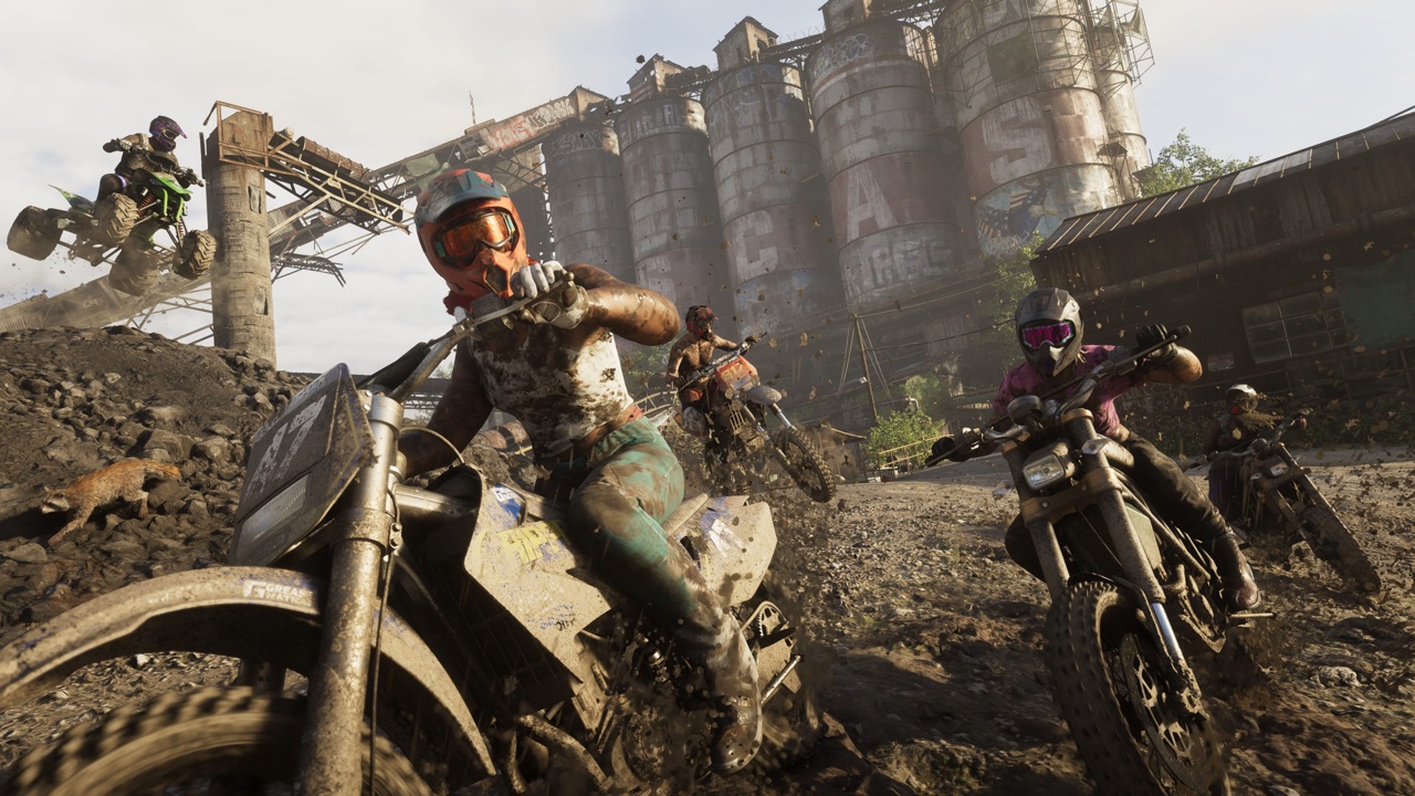
Why GTA 6 Feels Even Bigger Behind the Controller: Water & Verticality

691865), backcountry hunting trails, and 25+ BASE jump cliffs.Cartographic Measurement Methodology: How We Verified Leonida’s km²
To avoid pre-launch guesswork and inflated bounding-box claims, our scale benchmarks combine four reproducible in-game measurements across PS5 and Xbox Series X|S:
- 1. Highway Lane & Runway Calibration (Meters-Per-Unit Baseline): Standard interstate lanes across I-95 / Leonida Expressway and the main asphalt runway at Vice City International Airport (VCIA) establish a 1:1 metric baseline (
3.65 mstandard lane width), locking Zoom-6 map tiles to real-world meters. - 2. Shoreline Polygon Tracing vs. Bounding Box Separation: Tracing closed coastal and lakefront polygons isolates ~97.6 km² of strict dry land and ~28.0 km² of semi-aquatic Grassrivers mangrove islands and sandbars (~125.6 km² combined landmass), kept strictly separate from open Atlantic / Gulf border water.
- 3. Identical Projection Against GTA 5 (75.84 km²) & RDR2 (~35.9 km²): Applying the exact same polygon shoreline rule to Rockstar’s prior RAGE worlds yields 48.15 km² dry land / 75.84 km² total for GTA 5 and ~35.9 km² playable dry land for Red Dead Redemption 2 (excluding inaccessible Mexican Nuevo Paraíso geometry, Guarma’s isolated chapter island, and out-of-bounds Tempest Rim snowfields).
- 4. Live POI Density Cross-Check: Dividing our 3,487 verified map coordinates across ~125.6 km² of usable land produces an average density of ~27.8 interactive POIs per km² — confirming that Leonida is not merely larger than San Andreas and New Hanover, but substantially denser per block.
Frequently asked questions
How big is the GTA 6 map compared to GTA 5 in square kilometers and square miles?
GTA 6’s State of Leonida measures approximately 97.6 to 125.6 km² (37.7 to 48.5 sq mi) of playable landmass and roughly 151.8 to 185.0 km² (58.6 to 71.4 sq mi) when counting navigable interior waters, Lake Leonida, Grassrivers channels, and the Leonida Keys reefs. By comparison, GTA 5’s Southern San Andreas measures 75.84 km² (29.28 sq mi) in total map area including coastal water, with 48.15 km² (18.59 sq mi) of dry land — making GTA 6 roughly 2.0x to 2.6x larger in usable landmass.
How big is GTA 6 compared to Red Dead Redemption 2 (RDR2)?
GTA 6 features roughly ~3x the playable land area of Red Dead Redemption 2 (RDR2). RDR2’s accessible five-state frontier plus New Austin covers approximately 35.9 km² (13.86 sq mi) of playable dry land (inside a ~75.1 km² bounding box that includes Flat Iron Lake and inaccessible border mountains), whereas Leonida delivers ~97.6 to 125.6 km² of traversable dry land and wetland islands — roughly 2.7x to 3.5x (~3x) RDR2’s playable area.
Why did Red Dead Redemption 2 feel almost as long to cross as GTA 5 despite smaller km²?
Traversal speed and sightline framing create perceived scale. In Red Dead Redemption 2, a top-tier Arabian horse gallops at roughly 35 to 42 mph (56 to 68 km/h) along winding dirt trails, requiring 16 to 19 minutes to ride from Tumbleweed to Annesburg. In GTA 6, supercars exceed 180 mph on multi-lane interstate expressways and still require 11 to 14 minutes to drive from Southwind in the Leonida Keys to Mount Kalaga National Park.
Why do some GTA 6 map size studies cite ~98 km² while others cite ~125 km² or ~185 km²?
The difference comes down to water and wetland polygon boundaries. Strict dry-land shoreline tracing across Zoom-6 in-game tiles yields ~97.6 km² (37.7 sq mi). Including tidal mangrove islands across Grassrivers and shallow Key Lento sandbars brings usable land to ~125.6 km² (48.5 sq mi), while measuring the entire navigable bounding playspace with Lake Leonida and Keys reefs reaches ~151.8 to 185.0 km².
Does GTA 6 have more enterable buildings than GTA 5 and RDR2?
Yes. Launch cartography confirms more than 385 seamless enterable buildings across Leonida — including 45 bank branches and vaults, 131 convenience and liquor stores, 67 hotels and motels, pawn shops, nightclubs, and multi-floor residential towers — compared to fewer than 45 non-mission interiors in GTA 5 and roughly 125 frontier saloons, cabins, and general stores in RDR2.
How long does it take to drive or fly across the entire GTA 6 map?
A continuous highway drive from the southern tip of the Leonida Keys north through Vice City and Ambrosia into Mount Kalaga National Park takes 11 to 14 minutes in a fast sports car (versus 7 to 8 minutes around GTA 5’s Route 1/13 perimeter). Crossing coast-to-coast in a Buckingham Maverick helicopter takes roughly 4.5 to 5.5 minutes.
Which of GTA 6’s 6 regions has the highest pin density?
Vice City and Vice-Dale County hold the highest urban concentration with over 1,420 of our 3,487 verified map pins (including 7 of the 8 Large Bank Vaults, dense Collectible Card sets, and hundreds of transit and nightlife venues), while Mount Kalaga National Park and Grassrivers provide the largest uninterrupted wilderness and wetland expanses.